|
Careers / Students Your career in ... Construction Commercial Management Do you like to:
Then you should find out more about Civil Engineering Surveying What is Civil Engineering Surveying?
Civil Engineering Surveyors are involved in every stage of the project from the initial concept through the design and construction, to monitoring the condition and performance of the completed structure. Within this profession you could choose to work within Commercial Management (Quantity Surveying) or Geospatial Engineering (Engineering Surveying).
This profession also includes the
following functions:
Geospatial Engineers work within construction on the measurement and monitoring of projects as well as producing maps, plans and charts of different features. The main profession within civil engineering is engineering surveying (which is sometimes known as land surveying). Engineering surveyors are generally responsible for:
The term Geospatial Engineering includes the following specialist areas: Engineering surveying:
preparation of maps and plans for the planning and design of
structures as well as ensuring that the construction takes place to
the dimensions and tolerances required.
The civil engineering surveying profession provides an exciting and demanding working environment with the potential to develop a challenging and rewarding career. Many jobs involve working in the open air with opportunities for travel both in the UK and abroad.
You will need to have good GCSE passes in English, Maths and Science. There are then several different ways of progressing through your career. It is possible to develop at your own pace by studying through distance learning or by part time study. Alternatively you can take A levels and go to university to study a degree or diploma course. If you have just taken your A levels, you could consider taking one of the courses that the Institution of Civil Engineering Surveyors accredits. This means that the course meets all the ICES requirements which means that no more examinations are necessary to gain full professional membership. There are various courses available in both Commercial Management and Geospatial Engineering subjects. Contact the university direct for requirements to enroll on the courses (details given within the accredited courses lists as well as links to the university web pages). Want to find out more? The Institution of Civil Engineering Surveyors is the only international qualifying body dedicated exclusively to the education and professional advancement of those working within the fields of Commercial Management and Geospatial Engineering. Student membership of the ICES is available and indeed student members are warmly welcomed. By joining, you will become part of a lively and dynamic organisation committed to its members and to widening their recognition and influence throughout the construction industry. There are active regional groups across the country organising events and meetings to keep members in touch with the profession. Why should you join?
The Institution is committed to encouraging Student Members because it recognises that they are the future of the profession. To demonstrate this commitment, the Institution will cover all the costs of membership for those studying full time. Membership is therefore FREE for the duration of your course if you are studying full time or on a sandwich course. For those studying part time, membership rates are very reasonable. All you need to do is complete and return an application form, which can be downloaded here (in Microsoft Word format), countersigned by your course tutor, together with a passport size photo, and your membership can commence (the on-line Membership Enquiry form can be used for more general membership queries). There is no need to send copy certificates for A-level or GCSE qualifications, but if you have completed a course since then, can you please send copy certificates. For more information on this exciting and challenging career, contact the membership secretary at [email protected]. Home
| About
ICES | Civil
Engineering Surveying | ICES
Membership |
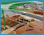 The civil engineering industry involves
the design and construction of the facilities which shape the world we
live in. From roads, railways and bridges to water supply pipes and
power stations, this is all civil engineering.
The civil engineering industry involves
the design and construction of the facilities which shape the world we
live in. From roads, railways and bridges to water supply pipes and
power stations, this is all civil engineering. Commercial Managers, or quantity
surveyors, are the financial managers of the civil engineering
industry. They work alongside other professionals in preparing the
documents on which projects are based, measuring the work completed on
site and ensuring that the companies carrying out the construction are
paid a fair price for it. Their responsibilities include:
Commercial Managers, or quantity
surveyors, are the financial managers of the civil engineering
industry. They work alongside other professionals in preparing the
documents on which projects are based, measuring the work completed on
site and ensuring that the companies carrying out the construction are
paid a fair price for it. Their responsibilities include: